

Riders – Byron / Trail Boss , John
Loop - 1100+ miles
Bikes – Orange 2006 KTM 950’s
Ride was the 2nd attempt of the June ride, when I had to drop out in downtown Boise because my 640 wouldn’t idle and the others had to reroute because of snow storms.
First trip on Betsy. She ran better and better the more miles she put on.
================================================================
FRIDAY
BOISE – OROFINO 350 MILES


Long Day, started to fade on the home stretch and my ass was killing me.
Took Cartwright / Dry Creek to HWY55, much more pleasant ride out of town.

Had the breakfast the KIT, of course Byron ran into someone he crossed paths with back in the day.
55 was closed up the road because of the Springs fire so we went through Sweet , Ola and High Valley to Smiths Ferry. We ran into the tail end of showers just past Donnelly and had a few sprinkles all the way into Burgdorf.

As we got to Freight Landing on French Creek it cleared up and smoke free !

Byron on French Creek.

Looking up French Creek canyon.

French Creek Grade
l

Salmon River into Riggins where we had lunch. We took 95 => Slate Creek => Grangeville – Salmon Rd => Grangeville.
On Slate Creek I saw a bear cub running down the road. We went east of Grangeville on Luke’s Gulch road down to Hwy 14.
Hwy 13 into Orofino was a pretty drive , but my ass was killing me and I was starting to fade because of the longer stretches sitting down.
Stayed at the High Country Inn in Orofino.

Mary Jo is the owner and originally from Bastrop , TX. Moved to North Idaho when her husband retired from the Air Force got a job with Army Corp of Engineering as a biologist on the Dworshak Reservoir project.


===================================================================================
SATURDAY
Orofino – Wallace ~ 180 miles A more relaxed pace than Friday.


Dworshak dam , tallest straight damn in North America.
Took the Elk River Byway into Elk River


Dent Bridge


Elk River was having a Huckleberry Festival

Met a couple of guys from Baker City at our fuel stop in Avery.

Avery was a train stop on the Milwaukee Line .


Dinner car on display


Took the Hiawatha Trail from Avery to I90 then over Look Out Pass into Wallace.
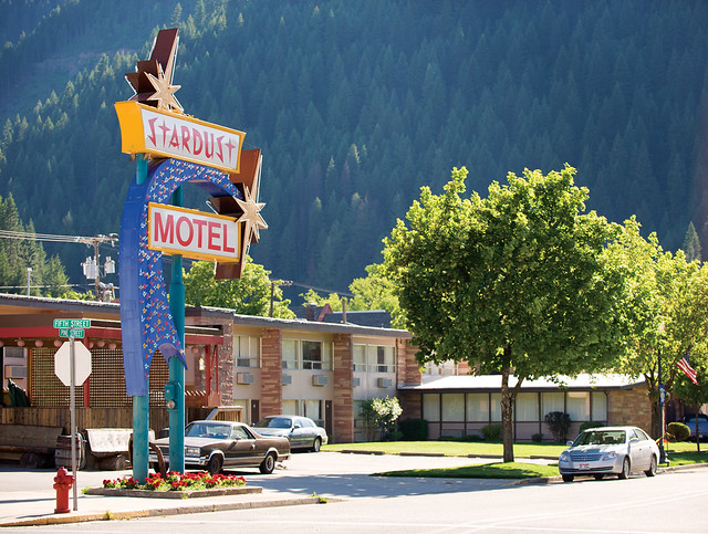

Our accommodations at the STAR DUST MOTEL in Wallace.

Wallace was just wrapping up an Accordion Festival . We just missed all the groupies .


Wallace had bustling bordello business as well as gambling up through the early 80’s until presuure from the FEDS shut them down. It also was the only Stop Light on I90 until the overpass was built. They put the light in coffin and had a funeral.

Had a steak dinner in the 1313.
============================================================================================
SUNDAY

Sunday morning we had a pancake breakfast at the Elks Lodge. 8AM was too early to see the musicians and groupies.


Our Sunday route took us over Moon Pass back into Avery, then along the St Joe River to St Mary’s .

Looking south over Moon Pass,

Sentinels from the 1910 BIG BURN largest fire in US history ~ 3 million acres.

Lunch in St Mary’s.
From St Mary’s we took back roads to Sky Line Drive in McCroskey State Park


Sky Line dropped us into the Palouse of Eastern Washington.

Site of a train collision Byron reported on when he worked as a reporter at a Colfax radio station


Steptoe Butte just north of Colfax , Washington.
We rolled into Lewiston ~ 6:30 PM and it was 101’F !
===============================================================================================
MONDAY


Lewiston – Boise , ~ 330 miles
We routed through Enterprise and Joseph to stay at higher elevations and cooler temps as long as possible.


Rattle Snake Grade has to be my favorite piece of asphalt.


Joseph Canyon

Shelby Cobra replica had a totally bad rumble.
Had lunch at the Embers in Joseph. Met a couple from Texas who were touring on a Gold Wing. They said it was 106’F when they rolled in Lewiston Saturday afternoon.


Views from the Hells Canyon Overlook of off FSR39. Ran into another couple on a Gold Wing from North Carolina and a family from Holland.
It was hot from here into Boise. We stopped for gas and a cold drink in Cambridge . I soaked my jersey in cold water when we left but it was dry before Midvale.
No comments:
Post a Comment